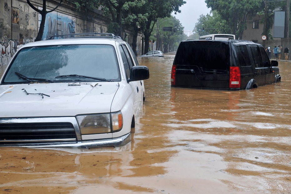
Urban floods has very adverse socioeconomic effects and can cause disruptions to city administration (eg, transport, sewerage, communication and electricity supply) and damage urban infrastructure. There is increasing concern that many areas of the world will be at risk of flooding, especially in urban areas with large populations and resources.
Urbanization
Urbanization and urban growth refer to the expansion in the share of the population living in urban areas. Urbanization alludes to the population shift from rural to urban, a decrease in the number of people living in rural areas.
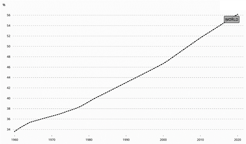
As of 2020, 56% of the world population is urban. (Urban Population (% of Total Population) | Data, n.d.)
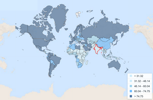
The figure shows the level of urbanization of all the countries with respect to population. Comparatively, India is less urbanized at present.
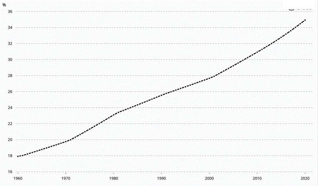
Our cities, occupy only 3% of the country’s land, however, their contribution to the GDP is an incredible 60%. In India, number of cities (census + statutory) has increased from 5161 in 2001 to 7935 in 2011
| City | Population in lakhs (2001) | Population in lakhs (2011) |
| Greater Mumbai | 163.7 | 184.1 |
| Delhi | 127.9 | 163.1 |
| Kolkata | 132.2 | 141.1 |
| Chennai | 64.2 | 87 |
| Bangalore | 56.9 | 85 |
Climate change
Climate change is a long-term shift in typical weather patterns that have come to characterize the world’s climate. These modifications have a broad spectrum of impacts that have been seen.
Effect of climate change
According to the report IPCC, climate change will have harsh impacts on the water systems. This leads to worsening the risks to economies, health and livelihood. Millions of people are already suffering as a result of these consequences on water systems, which are intensifying poverty, destabilising societies and turning life into a daily struggle for some of the most vulnerable categories. As a result, this will lead to aggravating the gender inequalities in access to safe water and sanitation and also the increase in water-related risks such as health & safety. (Jainer & Anand, 2021)
Water Cycle
Every year around 100 million people are affected by extreme flooding since 2015. Simultaneously, during this period in India, the districts affected by drought have increased to 13 times, affecting around 140.06 million people. (Jainer & Anand, 2021)
Sinking coasts
India has the longest shoreline in Asia at 7,500 km. As per the 2011 statistics, this length incorporates more than 486 urban centres that are home to around 41.7 million inhabitants. As per the tool hosted by NASA’s Sea Level Portal, sea-level rise is assessed to be 0.1 m to 0.3 m over the course of a few decades because of a worldwide temperature change. As indicated by the tool, coastal urban areas, (Jainer & Anand, 2021)
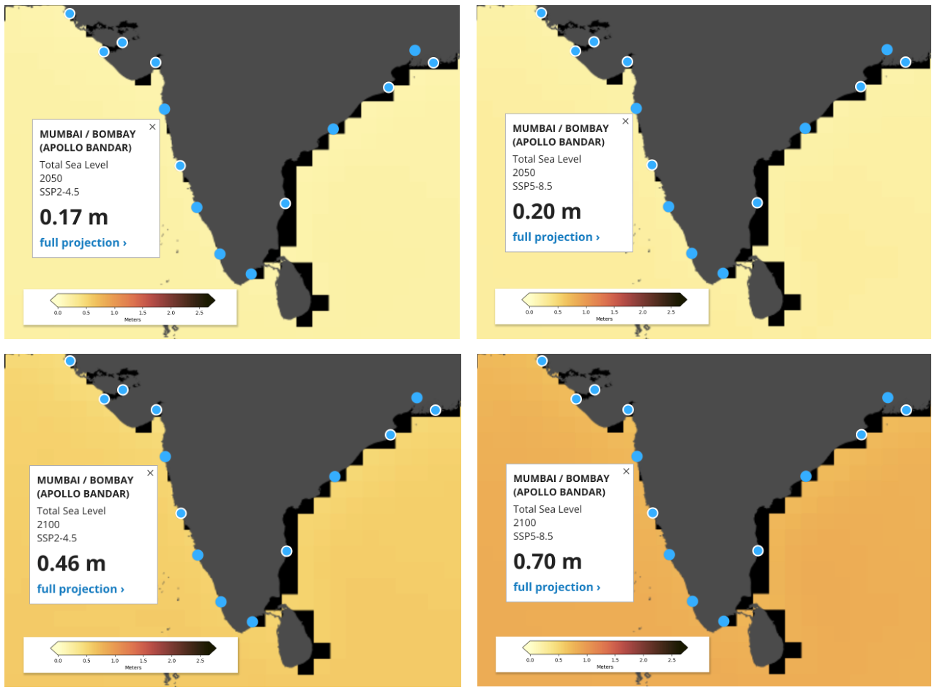
Source: Nasa Sea Level Portal, 2021 Level Portal, 2021
Urban heat stress
Increasing temperatures and more extreme temperature incidents have exacerbated the issue of urban heat stress and is causing deaths, hampering physical as well as mental health. Human-induced heat from transportation and buildings raises urban temperatures even more. Severe heatwaves in Indian cities could put people’s lives and health at risk, especially in low-income urban slum residents who live in poorly ventilated houses. (Jainer & Anand, 2021)
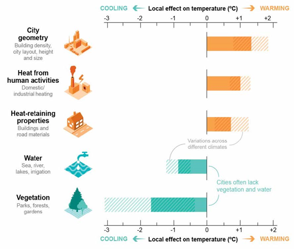
Source: (Jainer & Anand, 2021)
We will understand what is urban flooding, the various factors causing it followed by its impacts and consequences. Later we have tied to explore various ways in which steps can be taken/are already taken to reduce the adverse effects of urban flooding.
Floods
“Floods can be defined as the submergence of usually dry areas area by a large amount of water that comes from sudden excessive rainfall, an overflowing river or lake, melting snow or an exceptionally high tide.” (Government of India, 2017)
Types of floods
Based on the primary cause, floods can be categorised into three, namely- fluvial, pluvial and coastal floods.
Fluvial floods – When a rise in water level in a river, stream or a lake, due to excessive rain or snow melting, causes inundation of neighbouring land, it is called a fluvial or river flood (Insurance, 2020)
Pluvial floods – A flood independent of any water body, due to extreme rainfall alone is called a pluvial flood. It can happen in any area irrespective of its vicinity to a river, lake or ocean. It includes two types of floods-
- Surface water floods – They are characterised by overflowing streets and structures due to the insufficient capacity of existing urban drainage systems.
- Flash floods – They generally occur due to intense torrential rainfall within a short time period. (Insurance, 2020)
Coastal flooding is specific to coastal areas where the land is flooded by the adjoining seawater, due to intense storms, hurricanes, high tides and tsunamis.
Urban floods
When a developed urban region is flooded above the capacity of drainage systems (natural, manmade or both) of the city, it is called urban flooding.
Factors causing urban floods
The reasons for urban flooding are multi-faceted, and they can be understood as interactions between different natural (meteorological, hydrological) and man-made factors. We will take a closer look at a few of these factors.
Meteorological factors
It refers to the weather and climate conditions that can contribute to urban flooding in an area.
Extreme rainfall events
IMD has reported a three-fold rise in extreme rainfall events across India. Such rainfall events overwhelm the drainage systems in the cities and lead to flooding. For example, in 2015, when Chennai got flooded, it faced 345mm of rainfall on 1st December while the average rainfall for December was 191 mm. (Hari Ilam Vazhuthi & Kumar, 2020)
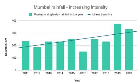
Mumbai’s rainfall – increasing intensity – shows steady growth in maximum single-day rainfall in a year in the last decade as we witness more frequent floods in the city.
Hydrological factors
These factors are mainly concerned with the distribution and movement of water on or below the earth’s surface. It is mainly because of the following phenomena.
Soil type
More pervious/porous soils allow higher percolation and increase the infiltration rates. Flood events occur when the rate of flood volumes is more than the maximum infiltration rate. (Hari Ilam Vazhuthi & Kumar, 2020)
Course of rivers
Rivers usually change course over time due to the shape of the basin, increased amount of water or other factors. Hence the immediately surrounding areas are at risk of fluvial or flash floods. (Hari Ilam Vazhuthi & Kumar, 2020)
Man-made / Human factors
These factors are solely dependent upon human activity and its impact on the natural and built environment.
Increase in built-up cover in cities
Urbanisation and development translate to an increase in the hard, impervious built-up cover and a reduction in natural, pervious surfaces in the cities. This leads to a reduced rate of percolation and an increased rate of surface run-off across the city. (Hari Ilam Vazhuthi & Kumar, 2020)

Source: (Goswami & Basak, 2020)
Considering the 10 most populated cities of India, between 2000 and 2015, 35% of the total new urban development (428 sqkm) has taken place in low-lying, vegetated areas with high recharge potential reducing the recharge capacities of the cities. These cities have flooded repeatedly between 2015 and 2020. (Goswami & Basak, 2020)
Encroachment
Many informal settlements and some planned as well, settle upon ownerless vacant land in the low-lying catchment areas of the water bodies. Such encroachments reduce the area for the natural flow of water while contributing to increasing the volume of water in the river basin leading to fluvial and flash floods in the surrounding and downstream areas. (Hari Ilam Vazhuthi & Kumar, 2020)
Grey infrastructure and pollution
In developing cities, there is generally some lag between the supply and demand of infrastructure facilities (waste disposal, sewerage, stormwater drains, STP). Also, unattended street waste ends up in the sewers and causes choking and silting, reducing the capacity and efficiency of the draining capacity of the cities.
Illegal sand mining
Illegal mining of sand for construction purposes depletes the natural bed of the rivers. This causes a change in the shape of the basin, and soil erosion and thus reduces the infiltration and water retention capacity leading to increased quantity and velocity of the river water. (Hari Ilam Vazhuthi & Kumar, 2020)
Unplanned release of water from the dam
The unplanned and sudden release of water from dams and lakes leads to floods in downstream urban areas, without giving the authorities and the people, enough time to respond appropriately. (Hari Ilam Vazhuthi & Kumar, 2020)
Absence of administrative framework
Until now there has been no initiative and political will from the government to place the water bodies as a protected environment or no development zones. Instead, the local governments have regularized the development in such areas. (Hari Ilam Vazhuthi & Kumar, 2020)

Source: (Hari Ilam Vazhuthi & Kumar, 2020)


Case Study- Mumbai – Causes of Urban Floods
With an aim of understanding the causes of urban flooding in a comprehensive manner, the frequently flooded cities of Mumbai.
Profile of Mumbai
The coastal city of Mumbai is made up of two island groups and stands at an average elevation of 10-15 meters above sea level. The city observes a tropical climate and average annual precipitation of 242 cm.(Gaurkhede et al., 2021)
Susceptibility to flooding
Mumbai is particularly vulnerable to disasters due to being a coastal metropolis with low-lying and hilly sections, as well as the seismicity of the landmass. Human actions have further increased this vulnerability. (Singh & Vijhani, 2016)
Land Reclamation
The seven islands which were once separated by swampy areas were first joined, mainly to accommodate the increasing population in the fort area. Thereafter, several reclamations were carried out to connect various parcels of land till 1845. The total reclaimed area in Mumbai is 96 sq. km.(Gaurkhede et al., 2021)
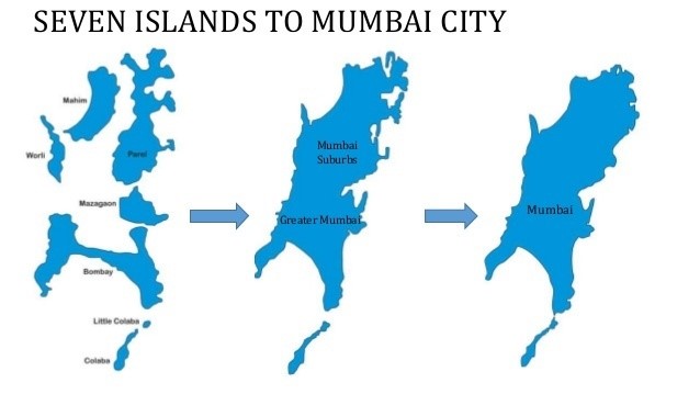
Source: google images
Source: Mumbai Technical Support Unit report, 2015
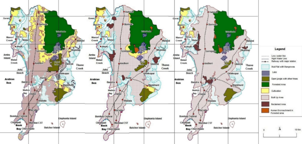
Developments in river basins
Mumbai has rivers Mithi, Dahisar, Poisar, Mahul, and Oshiwara which discharge directly into the Arabian Sea. Mithi river acts as the major component for natural drainage, running across the city with a catchment of approximately 108 sq. km. These basins have now been built upon with roads, buildings and slums. Mumbai lost 71% of its Mangroves from 1970 to 2014.(Gaurkhede et al., 2021)


Source: Mumbai Floods- Case Study on Floods in Reclaimed City
Design and Capacity of Drainage Systems
The city has a combination of natural and man-made drainage systems. The existing drainage system for stormwater is 80 years old and has a very insufficient capacity of carrying just 25 mm of water/hour. Improper waste management and sewage from areas without any proper sewage system also lead to clogging of the drainage system. Out of 105 outfalls, only 3 have floodgates. (Gaurkhede et al., 2021)
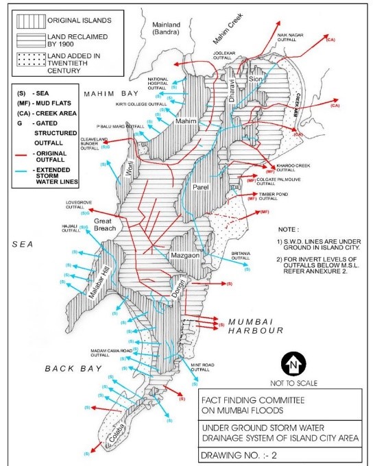
Source: Identification of Interruptions in Urban Drainage Systems and Their Sustainable Solutions for Alleviating Flood Risk in Mumbai, an Indian Megacity.
Increased runoff coefficient
Rapid changes in land use and land cover has been observed majorly due to migration of people.
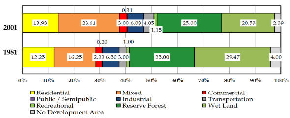
Source: Identification of Interruptions in Urban Drainage Systems and Their Sustainable Solutions for Alleviating Flood Risk in Mumbai, an Indian Megacity.
The figure shows the tremendous increase in built density of the urban areas and this is done at the cost of forests, farmlands and rivers. Urbanization has led to an increase in the run-off by almost 3 times. (Gaurkhede et al., 2021)
Impacts and consequences of urban flooding
In the densely populated urban context, the number of people affected by urban floods is huge. The damages caused by the urban floods can be categorised as tangible and intangible losses.
Tangible losses
These are the losses that can be measured physically and can be assigned an economic value. It includes impacts like washing away of temporary tenements, damage to commercial assets and physical infrastructure, increase in prices of goods, and people getting stranded. Due to the high economic primacy of urban centres, the economic losses are very high. (Hari Ilam Vazhuthi & Kumar, 2020)
Intangible losses.
It includes loss of life, secondary health effects, damage to the environment, emotional and mental turmoil, and the spread of diseases, all of which are difficult to quantify in terms of money. Due to high population density, the number of lives affected is large and such an event can affect the morale and spirit of the city. (Hari Ilam Vazhuthi & Kumar, 2020). It also includes the various social impacts during the post-flood recovery process.
Urban flood management solutions
Taking reference of some of the best practices globally, some of the identified flood management solutions are as follows:
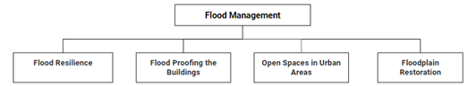
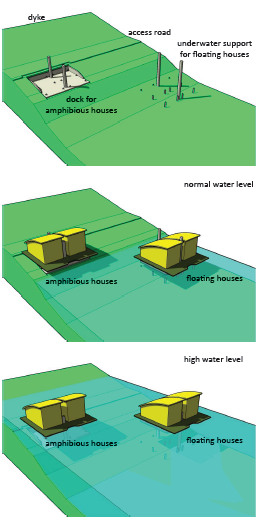
Flood Resilience
Flood resilience deals with how can a city cope with and tolerate flooding. Cities need to take into account that it is not feasible to rely on Flood Control Infrastructure and that it is extremely necessary to adopt measures for flood resilience due to factors like climate change and change in river courses, etc. An excellent example of Flood Resilience is Yokohama in Japan which has adopted different measures for flood resilience at varying scales. (NITI Aayog Report, 2021)
Source: Tokyo Development Learning Center
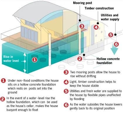
Flood Proofing the Buildings
The concept of flood proofing takes into account the techniques, emergency or permanent, which would minimize the damage caused to the built form due to flooding. Such techniques may include construction on stilts, use of hollow foundations, using materials which are water-resistant, etc. An example of this is the floating house of Maasbommel in Netherlands. (NITI Aayog Report, 2021)
Source: Financial Times
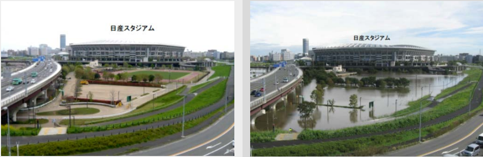
Open Spaces in Urban areas
This concept works on the principle of directing the excess stormwater to the open spaces, which will help in preventing the built structures from the adverse effects of flooding. These urban open spaces may be multi-functional while adopting techniques for stormwater retention. Systems for floodwater storage and conveyance may also be integrated with these open spaces. An example is the Indian Bend Wash in Scottsdale, Arizona, which temporarily retains the floodwater at times of flooding. (NITI Aayog Report, 2021)
Floodplain Restoration
Depending on the type of vegetation, floodplains or the banks of water bodies largely affect the level of flooding. These floodplains mitigate the floods majorly due to their absorptive capacity. It is very important to restore floodplains as they also provide habitats for different plant and animal species. The floodplain restoration of River Skerne in the U.K. is one such example. (NITI Aayog Report, 2021)

Source: River Restorations – Case Studies, Geo Factsheet
Blue-green infrastructure
The existing stormwater drainage systems consist largely of grey infrastructure which is now facing issues due to increased run-off, temperature variations, etc. These systems are also no longer sufficient and hence, there is a need to adopt new methods. One such method is the integration of Blue-green infrastructure (BGI) with traditional grey infrastructure for providing sustainable flood management to tackle the upcoming flooding. BGI is defined by the European Commission as a ‘strategically planned network of natural and semi-natural areas with other environmental features designed and managed to deliver a wide range of ecosystem service’. (Living with Water, n.d.)

Source: WRI India
Case studies
Blue-Green Infrastructure is now being identified as an important tool in urban flood management due to its applicability at multiple scales. 3 case studies, adopted at different scales, have been identified.

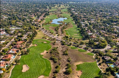
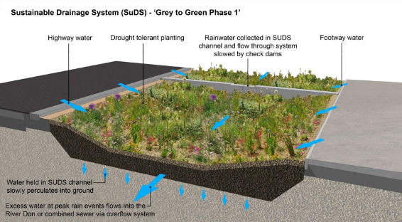
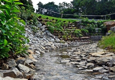
Case Study – Street scale – Sheffield, UK
UK adopted the “Grey to Green” scheme, which is a sustainable stormwater drainage project, in 2014 for one of the streets which was reduced from 4 lanes to 2. (“Grey to Green,” 2020)


Source: Grey to Green, nigelldunnett
Functions of the project
The street runs alongside the Don River and hence is extremely prone to flooding. Hence, one of the major function of this scheme is to help in reducing and retaining the stormwater runoff.
Blue-Green Infrastructure adopted:
BGI elements like permeable pavements, bio-swales, rain gardens and retention basins are adopted.
Source: Grey to Green, nigelldunnett
SDGs addressed:

Source: United Nations
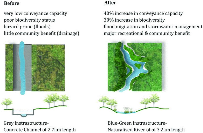
Case Study – Neighbourhood scale – Bishan Ang Mo Kio Park, Singapore
The conversion of concrete channels for drainage to a natural river through the Bishan Ang Mo Kio Park in Singapore is a very good example of the use of BGI not only for flood prevention but also for other benefits like improved health of residents. (Schaefer, 2014)
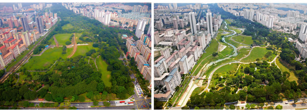
Source: Bishan Ang Mo Kio Presentation, issuu
Functions of the project:
The idea of converting the channel to a river through the park was for the purpose of using the parkland as a flood plain to mitigate urban flood challenges.
Blue-Green Infrastructure adopted:
Soil bioengineering techniques were adopted for the process of naturalization of the river, which increased the carrying ability by more than 40%. (Schaefer, 2014)
Source: Bishan Ang Mo Kio Presentation, issuu
Source: Bishan Ang Mo Kio Presentation, issuu
SDGs addressed:

Source: United Nations
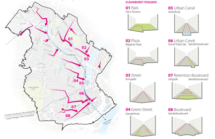
Case Study – City scale – Copenhagen, Denmark
Copenhagen has adopted a city-wide cloudburst management plan with uses Blue Green Infrastructure elements at different scales to mitigate the effects of flooding due to cloudbursts.(Cloudburst Management Plan, Copenhagan | Oppla, n.d.)
Cloudburst Management Formula
A six-step procedure for integrating the Blue-Green Approach was adopted.

Source: Cloudburst Management Plan, Copenhagen
Blue-Green Infrastructure Adopted:
Elements like urban canals, plazas, boulevards, green streets have been proposed throughout the city for making the city flood resilient, seen in figure 39. (Cloudburst Management Plan, Copenhagan | Oppla, n.d.)
Source: Cloudburst Management Plan, Copenhagen
SDGs addressed:

Source: United Nations
Relevant planning measures in India
Bhopal Development Plan 2031 has provisions for the conservation of Bhojtal, land abutting the Upper lake and its catchment area by demarcating it as highly sensitive area. For conservation of these zones, Bhojtal Catchment area is considered a separate zone – Catchment zone (CZ). It is classified into subzones for specifying the permissible activities in each zone. (similar to CRZ regulations).
Bhojtal (CZ 0)
Catchment Zone 1 (CZ 1)
Catchment Zone 2 (CZ 2)
Village Abadi (V)
Village Abadi Extension (VE2)
There are several other proposals for the conservation of water bodies to maintain the natural ecosystem of the city. All these initiatives will conserve the water bodies and the wetlands, which is a step towards better flood management in the face of climate change and rapid urbanization.
Different catchment zones can be seen in Map 1 Bhojtal Lake and Catchment zones

Draft Master Plan for Delhi 2041
Some salient features of the plan with respect to green-blue infrastructure are-
- Enhancing green-blue infrastructure
- Preservation and improvement of natural green and blue assets
- Creation of new green-blue assets
- Enhancing green-blue features in the built fabric
- Management of green-blue infrastructure
The green belt and the preserved floodplains are visible in the Map 2 Draft Land Use Plan, Delhi

Source: Draft Master Plan for Delhi, 2041
Use of technology
Technology plays a major role in the mitigation of disasters. Space technology which uses remote sensing, along with GIS, proves to be highly beneficial for flood control in the near future.
Space Technology:
The ability of satellites to provide large-scale and multi-temporal coverage regularly and frequently make them ideal methods for mapping as well as studying and monitoring the dynamics of floods.
Satellites which include geostationary, meteorological and communication satellites, are a part of space technology and provide valuable information for timely warning and flood management.
GIS application in flood management:
GIS is extremely useful when it comes to the identification of flood-prone areas. Stricter and better practices for floodplains can be implemented in these areas which have been identified with an aim of mitigating floods.
Modelling and simulations
Storm Water Management Model
United States Environmental Protection Agency’s (EPA) Storm Water Management Model (SWMM) is an open-source software used for a single event or long-term simulations of water run-off quantity and quality in primarily urban areas. (EPA, n.d.)


Hydrodynamic modelling
Hydrodynamic modelling is the study of fluids in motion. Hydrodynamic models are effective to represent and study the flood water dynamics. These numerical computational models can be used to simulate currents, water levels, sediment transport and salinity. (Intertek, n.d.; The Conrad Blucher Institute, n.d.)


CFLOWS, Chennai
CFLOWS in Chennai is India’s first Integrated Coastal Flood Warning System. It’s an integrated GIS-based decision support system to provide a forecast of possible flood events up to 10 days in advance. (Chaitanya, 2019)
IFLOWS, Mumbai
IFLOWS is the monitoring and flood warning system in Mumbai, which is able to alert the city of possible area-wise flood events, six to 72 hours in advance based on 165 stations across the city. (Bhalero, 2020)
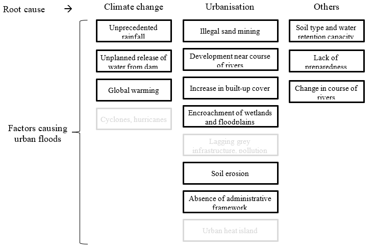
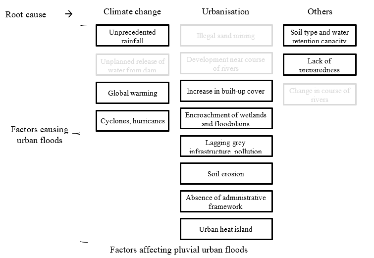
Factors responsible for urban flooding
With the knowledge from the above references, we will try to compare the impacts of different factors on the flood incidents and the flood volumes in an urban context. We will analyse the different factors and their root causes, judging upon which of the root causes are more damaging in the form of urban floods.
Results and Discussion
The factors responsible for urban flooding are categorized into 3 groups – Climate change, Urbanization and Others, based on the root cause behind each factor.

From the above set of cause and factors, the subset that causes fluvial urban floods are identified as shown below
Similarly, factors for pluvial urban floods are shown below
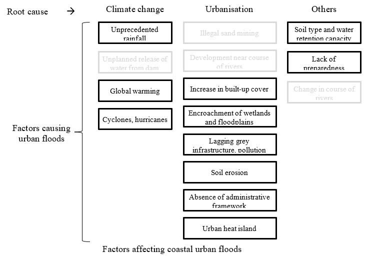
Even though urban flooding may seem like a natural disaster which happens to occur in an urban context, it is not a completely natural phenomenon. As evident from the above comparison, the factors due to human activities can be equally responsible for inundations. This observation points toward the adverse impacts of our unchecked aspirations and ambitions. It is necessary to understand each and every aspect of the way our actions are altering the natural and built environment around us.
Conclusion
Major causes of urban floods constitute manmade factors and hence, it is imperative to plan urban areas in such a way that the environment is given due consideration. Researchers and practitioners from varied fields should cooperate for this purpose.
Way forward
There is a need to take into consideration alternative storm-water management techniques. New perspectives need to be adopted. Alternatives to grey infrastructure need to be studied and implemented in developing cities to help manage the stormwater run-off. The combination of climate change, increasing urbanization, demands for housing and industrial lands (often in the floodplains), and economic development are a few of the issues which need to be looked into in a comprehensive manner for increasing adaptation and enhancing community resilience.
Failure to incorporate both urban flood management and climate change into current decision processes could lead to future unnecessary costs, wasted investments and risks to life and property. Failure to factor in both urban flood control and climate change into present decision-making processes might result in future wasteful expenses, squandered investments, and life and property threats.